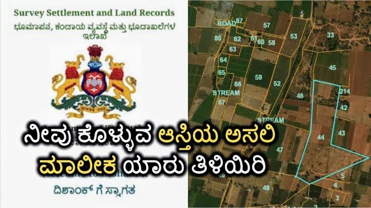
In today’s digital era, land ownership disputes and verification have become a major concern, especially in states with high real estate activity like Karnataka. To tackle this issue, the Government of Karnataka launched the Dishaank App, a revolutionary mobile application developed by the Karnataka State Remote Sensing Applications Centre (KSRSAC) under the Karnataka Geographic Information System (K-GIS) initiative. This app is designed to bring transparency, accessibility, and accuracy in identifying land details, including ownership, location, and type.
Whether you are a farmer, a buyer, a landowner, or just someone verifying property boundaries, the Dishaank app can be your go-to tool for land survey and ownership-related information.
—
📱 What is the Dishaank App?
The Dishaank app is a mobile application that allows users to access land survey records for any location in Karnataka. By simply using your smartphone’s GPS or selecting a location on the app’s map interface, you can view crucial details such as:
Survey Number
Land Type (e.g., Dry Land, Wet Land, Forest, Government Land)
Area
Landowner Information (if linked with Bhoomi RTC)
Geographical Boundaries
It is available for both Android and iOS platforms and has crossed over a million downloads.
—
🔍 How the App Helps in Identifying Land Ownership
One of the most critical uses of the Dishaank app is identifying who owns a particular piece of land. Here’s how it works:
1. Locate the Land: You can either use GPS or navigate the in-built map to find the land in question.
2. Survey Number Retrieval: Once you select the land area, the app shows the official survey number registered with the Revenue Department.
3. Access RTC Details: If the Dishaank app is connected with Bhoomi (Karnataka’s land records portal), it will also show the name of the registered landowner and associated details.
4. Cross-Verification: Users can cross-check this information with RTCs (Record of Rights, Tenancy, and Crops) for legal purposes or ownership disputes.
This helps people verify if a seller is the actual owner of the land, reducing chances of fraud or illegal transactions.
—
🌾 Benefits for Farmers and Land Buyers
For farmers, Dishaank offers a digital tool to monitor their land boundaries, understand land type for crop suitability, and even submit corrections if there are errors in survey data.
For land buyers and investors, the app is a powerful verification tool before purchasing land. You no longer need to rely solely on agents or revenue officials. All the basic details are available at your fingertips.
—
💡 Key Features of Dishaank
Feature Description
Map-Based Interface Interactive GIS map that helps users identify survey numbers and land boundaries.
Real-Time Location Tracking Shows the land parcel based on your GPS location.
Ownership Details Displays Bhoomi-integrated owner info for authenticated plots.
Land Use Classification Differentiates between forest land, agricultural land, government land, etc.
User Feedback Option Users can raise complaints or suggestions if land data is incorrect.
—
🏢 Who Developed Dishaank?
The Dishaank app is developed by KSRSAC (Karnataka State Remote Sensing Applications Centre), a government body responsible for satellite data usage in planning and management. It is built under the larger K-GIS program, a flagship initiative to digitize Karnataka’s spatial and land data systems.
The data inside the app is fetched from the Survey Settlement and Land Records (SSLR) department and is closely integrated with the Bhoomi RTC database.
—
⚠️ Limitations and Common Issues
Although the Dishaank app is highly useful, it comes with a few limitations:
❌ Not all survey numbers have updated or verified ownership data.
📶 App performance may depend on internet connectivity and GPS accuracy.
🛠️ Some users report bugs or login issues, especially on the iOS version.
🔒 Sensitive ownership information may be restricted to authorized users or departments.
—
🧠 Tips for Using Dishaank Effectively
1. Use it along with Bhoomi portal for deeper ownership verification.
2. Enable GPS and allow location permissions for best results.
3. Take screenshots of land details for records during purchase or disputes.
4. Report discrepancies immediately using the feedback section in the app.
—
🌐 How to Download the App
Android: Download from Google Play Store
iOS: Download from Apple App Store
—
📝 Final Thoughts
The Dishaank app marks a major step in Karnataka’s digital governance initiatives, especially in land management. It empowers citizens with access to transparent, official land records and simplifies ownership identification—something that was earlier a complex, offline process. Whether you’re a common man, farmer, investor, or government official, Dishaank is a must-have tool to make informed decisions about land.